
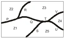
The diagram below shows a river system consisting of 7 segments, marked P, Q, R, S, T, U, and V. It splits the land into 5 zones, marked Z1, Z2, Z3, Z4, and Z5. We need to connect these zones using the least number of bridges. Out of the following options, which one is correct?
Correct Answer :
Bridges on Q, R, T, and V
Solution :
The correct option is Bridges on Q, R, T, and V.
Step-by-Step Explanation:
1. Understanding the Problem as a Graph:
We can model this geographical problem using graph theory. Let the land zones (Z1 to Z5) represent the nodes (vertices) of a graph, and the potential bridge locations crossing the river segments (P, Q, R, S, T, U, V) represent the edges connecting these nodes.
Based on the network connections in the diagram:
• There are 5 zones: Z1, Z2, Z3, Z4, and Z5.
• There are 7 potential bridge locations: P, Q, R, S, T, U, and V.
2. Finding the Minimum Connections Needed:
To connect any group of n isolated nodes so that every node is reachable from every other node without creating redundant loops (forming a spanning tree), the minimum number of connections (edges) required is:
3. Evaluating the Connections:
Let us examine the connections provided by the bridges in the correct option (Q, R, T, and V):
• Bridge Q connects zone Z1 and zone Z3.
• Bridge R connects zone Z2 and zone Z3.
• Bridge T connects zone Z3 and zone Z5.
• Bridge V connects zone Z3 and zone Z4.
By building bridges at these four locations, Z3 acts as a central hub. From Z3, you can directly access:
• Z1 (via Q)
• Z2 (via R)
• Z5 (via T)
• Z4 (via V)
Thus, all five zones Z1, Z2, Z3, Z4, and Z5 are fully connected, allowing us to visit every zone by crossing exactly these 4 bridges.
Access expert-curated educational resources and study materials—completely free.
Create, conduct, and manage professional online assessments with Mindyard. Perfect for teachers and institutes.
Copyright © 2026 Mindyard. All Rights Reserved.